Disclaimer: This project was completed during Rob’s tenure as the Technical Delivery Director at Astute Communications (2022-). Odyssey Behavioral Healthcare was not, and is not, a client of Petrin Development Services.

Overview
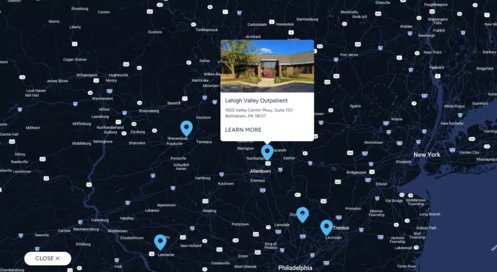
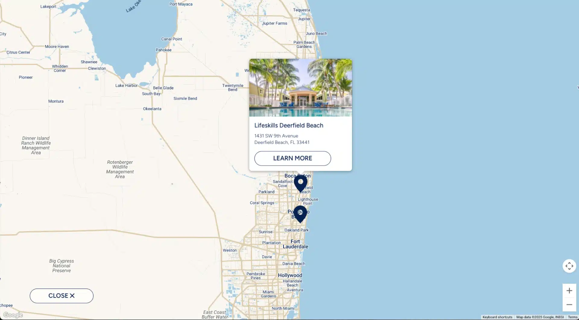
Odyssey Behavioral Healthcare operates a nationwide network of over 20 treatment facilities across seven states, providing specialized behavioral health services including psychiatric care, substance use treatment, and eating disorder programs. For their website initiatives spanning Pennsylvania and Florida markets, the organization required sophisticated location-based user experiences that could immediately communicate proximity relationships and accessibility while providing rich, interactive discovery experiences for their service locations.
The challenge involved developing a comprehensive mapping platform that could adapt across different organizational contexts while maintaining consistent functionality and visual appeal. Rather than relying on static location pages or basic embedded maps, the solution required custom interactive mapping with intelligent zoom behaviors, rich content integration, and responsive design that worked seamlessly across devices and use cases.
This project demonstrates the evolution from traditional location-based content management toward dynamic, user-focused geographic interfaces that enhance discovery and engagement while providing a reusable framework for future client implementations.
The Challenge
The Odyssey mapping initiative represented a convergence of technical limitations, evolving best practices, and cross-client scalability requirements that pushed beyond conventional WordPress location management approaches.
Legacy Mapping Limitations: Traditional approaches to custom map styling relied heavily on local JSON configuration files—a methodology increasingly deprecated by major mapping providers. This created technical debt and limited customization options, particularly for organizations requiring branded map experiences that aligned with their visual identity and user experience standards.
Complex Data Integration Requirements: The solution needed to populate interactive maps directly from WordPress custom post data, including featured images, location titles, addresses, and permalink relationships. This required seamless integration between WordPress’s content management capabilities and Google Cloud Platform’s mapping services, with real-time data synchronization and dynamic marker generation.
Sophisticated User Experience Expectations: Rather than simple pin-drop functionality, the mapping solution required intelligent behavior patterns. This included automatic zoom-to-fit for all locations on initial load, dynamic zoom-in functionality when users selected specific markers, and intelligent zoom-out behavior when dismissing detailed location views. The interface needed to maintain spatial context while providing detailed location information through rich marker interactions.
Cross-Platform Scalability: The mapping solution needed to function consistently across Odyssey’s Pennsylvania and Florida website implementations, each serving different regional markets with varying content structures and branding requirements. This required developing a flexible architecture that could adapt to different organizational contexts while maintaining code reusability and maintenance efficiency across both deployments.
Responsive Design Complexity: The mapping interface required dual-mode functionality: a compact, preview-only view for standard page layouts and an expandable full-screen mode for detailed location exploration. This dual-state requirement created significant technical challenges for responsive design, user interface transitions, and maintaining map functionality across different viewing contexts.
The core challenge became: How to create a sophisticated, interactive mapping platform that could serve diverse client needs while advancing beyond deprecated mapping methodologies and providing a scalable foundation for future implementations?
The Solution
The solution approach centered on developing a comprehensive custom mapping platform using modern Google Cloud Platform integration while creating a reusable framework that could adapt across different client contexts and organizational requirements.
Technology Stack & Custom Development
The Odyssey mapping platform required extensive custom development built on enterprise-grade mapping infrastructure with sophisticated WordPress integration capabilities.
Core Platform:
- WordPress with Advanced Custom Fields Pro – Enterprise content management foundation with flexible field architecture
- Google Cloud Platform (GCP) – Cloud-based mapping infrastructure with advanced customization capabilities
- Google Maps JavaScript API – Modern mapping framework replacing deprecated local JSON styling approaches
- Custom Gutenberg Blocks – Native WordPress block development for seamless content editor integration
Custom Development Scale:
- Proprietary mapping block architecture with dynamic data population from WordPress custom posts
- Advanced marker management system with real-time content synchronization
- Custom map styling engine leveraging GCP’s cloud-based customization tools
- Sophisticated zoom and pan behavior logic for intelligent user experience management
- Responsive dual-mode interface supporting both embedded and full-screen viewing experiences
Integration & Performance:
- Real-time WordPress custom post data integration with automatic map marker generation
- Advanced caching strategies for optimal map loading performance across different network conditions
- Cross-client adaptability framework enabling rapid deployment across different organizational contexts
- Mobile-optimized responsive design with touch-friendly interaction patterns
Intelligent Mapping Behavior
Dynamic Content Integration: The solution automatically generates interactive map markers from WordPress location custom posts, pulling featured images, titles, addresses, and permalink data in real-time. This eliminates manual map maintenance while ensuring content consistency between location pages and map representations.
Sophisticated Zoom Management: The platform implements intelligent zoom behaviors that enhance user experience through contextual spatial awareness. Initial map loads automatically calculate optimal zoom levels to display all location markers within the viewing area, while marker interactions trigger smart zoom-in functionality that highlights selected locations without losing spatial context.
Dual-Mode Interface Architecture: The mapping solution operates in two distinct modes: a compact preview mode suitable for standard page layouts with limited interactivity, and an expandable full-screen mode that unlocks complete mapping functionality. The transition between modes maintains user context while adapting interface controls and navigation options appropriately.
Cross-Platform Adaptability Framework: Rather than creating client-specific implementations, the solution establishes a flexible framework that adapts to different organizational requirements through configuration rather than custom development. This approach enabled rapid deployment from Pennsylvania healthcare networks to Florida educational services while maintaining consistent functionality and user experience standards.

The Outcome
The Odyssey mapping platform successfully delivered sophisticated location-based user experiences while establishing a reusable framework that has proven valuable across multiple client implementations and organizational contexts.
Technical Architecture Success: The transition from deprecated local JSON styling to modern Google Cloud Platform integration future-proofed the mapping solution while enabling advanced customization capabilities that weren’t possible with previous methodologies. The custom Gutenberg block architecture provides seamless content editor integration that empowers non-technical users to manage location content without requiring developer intervention.
Cross-Client Deployment Efficiency: The adaptable framework approach validated its effectiveness through successful implementation across Odyssey’s Pennsylvania and Florida regional websites. Each deployment required minimal customization while maintaining sophisticated functionality and visual consistency, demonstrating the value of reusable development frameworks for multi-site organizational needs.
Enhanced User Experience Delivery: The intelligent zoom behaviors and dual-mode interface architecture significantly improved user engagement with location-based content. Organizations reported improved user interaction with their location discovery tools and enhanced accessibility for users seeking proximity-based service information.
Development Framework Value: While the sophisticated technical implementation may not always receive recognition from non-technical stakeholders, the platform’s reusability and adaptability have proven valuable for future client projects. The framework approach enables efficient deployment of complex mapping functionality while maintaining high standards for user experience and technical performance.
Platform Longevity and Scalability: The modern Google Cloud Platform foundation and custom WordPress integration continue to operate effectively across multiple client implementations, validating the architectural decisions and development approach. The platform’s ability to adapt to different organizational requirements while maintaining consistent functionality demonstrates the strategic value of investing in sophisticated, reusable development frameworks.


